Fraser Island
Fraser Island is the largest sand island in the world at 360 square miles. It was inscribed as a World Heritage site in 1992. Fraser Island is located off the east coast of Australia approximately 200 kilometres north of Brisbane, Queensland. With Cooloola, the island forms the Great Sandy Region, stretching 175 km north to south, varying in width up to 25km, with the highest elevation of 260 metres.  The Fraser Island area is protected in the name of Great Sandy National Park. The bay of water known as Hervey Bay was so named by Captain James Cook during his navigation of the east coast of Australia in 1770. He thought that Fraser Island was joined to the mainland and the sheltered waters behind it were a bay. But the first inhabitants of Australia were the Aboriginal people whose history, though unrecorded, is now believed to date back to before the Ice Age. Evidence from Tasmania indicates some Aborigines survived the Ice Age by living in caves.
  Their history began in a time they call the Dreaming, when the Ancestor Spirits emerged from the earth and gave form to the landscape. Anthropologists believe that Aboriginal peoples reached eastern Australia at least 40,000 years ago. Tribes lived in the area now known as Fraser Island and Hervey Bay until the English arrived and caused violent disruption to their lives. It was during this time in 1836 when a number of survivors of the wrecked ship 'Stirling Castle' lived for about six weeks on the island before being rescued. During these six weeks, hostility and aggression developed between the Europeans and the Aborigines. One of the survivors was the wife of the captain of the Stirling Castle, Eliza Fraser
 after whom Europeans named the island. Day-to-day management of the island is primarily the responsibility of the Queensland Parks and Wildlife Service. Named after shipwreck victim Eliza Fraser this World Heritage listed sub tropical island has a truly amazing array of natural wonders including beautiful rainforests, pristine lakes, endless surf beaches, immense sand blows, cliffs of coloured sands, crystal clear streams and vast stretches of mangroves.
The Island is 125km long and over 160,000 hectares in area. It was formed during the ice age when the prevailing winds transported the vast quantities of sand from New South Wales and deposited it along the coast of Queensland forming the island as we know it today.
 Ambitions of the European squatters and settlers to acquire the land around Maryborough, Fraser Island, and Hervey Bay, without thought or reference to the Aboriginal inhabitants, resulted in predictable conflict. The actions of a few Aboriginals were more than outweighed by the horrors inflicted on local tribes by white settlers. Poisoning of waterholes and serving up meals of flour and bran laced with strychnine and arsenic were among the ways the whites dealt with the black "problem".
Wholesale slaughter of hundreds of innocent Aboriginals took place in retribution for the actions of a few. Settlers enlisted renegade blacks from further south to act as native police, assisting their mass killings of fellow Aboriginals and providing a convenient excuse when blamed for the bloody raids.  Mainland Aboriginals were exiled to Fraser Island, but here too they were persecuted, with many being driven into the sea to their deaths on Christmas Eve of 1851 by native police under the local white commandant.
Timber felling and sand mining for minerals became big industries on the island during the twentieth century, but all that ceased when Fraser Island attained its World Heritage Listing in December 1992 in recognition of the island's exceptional sand dune systems, its rainforests on sand, and its beautiful freshwater lakes.
LAKES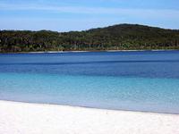
There are over 40 different lakes on the island, each unique. The lakes on Fraser Island are arguably the most pure clear lakes in the world due to the filtering effect of the sand. This is also matched with the most pure white beaches caused by the constant rise and fall of the lake leaching out any impurity in the sand leaving only pure silica. The lakes are formed in three different ways.
Each of the lakes has its own particular character. Mysterious, moody and beautiful, they are excellent subjects for photography, great places to see birds, other fauna and flora and a welcome oasis on hot summer days. Scenic 4WD circuits and walking tracks in the southern half of Fraser Island take in some of the largest of the lakes including McKenzie, Birrabeen, Benaroon and Boomanjin. There is a walking track to Lake Wabby from the beach.
Windowlakes
 Window Lakes such as Yankee Jack, Ocean Lake and Lake Wabby are formed when the ground drops below the natural water table. Lake Wabby is especially unique as it is formed by the damming effect of a sand blow blocking the waters of a natural spring. Wabby is close to the eastern beach side of the island and unlike the other lakes it supports several species of fish.
Perched Lakes Perched lakes such as Lake Bowarrady which is 120 meters above sea level are formed by rainwater being caught in saucer-shaped depressions with a hard impervious base of organic matter. Lake Boomanjin at approximately 190 hectares in total area and is the Australia’s largest perched lake. Other perched lakes on the island include Lake Birrabeen and the very popular Lake McKenzie.
Barrage Lakes.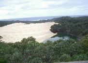
The island also has several barrage lakes, formed when moving sand dunes block a watercourse, and 'window' lakes, formed when a depression exposes part of the regional water table. There are many sand blows that cause Barrage Lakes.
Eli Creek
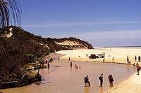
 Throughout the island there are fractures in the dunes and the water table is exposed in window lakes and springs which create freshwater streams in profusion. The largest and most attractive on the eastern shore is Eli Creek, which winds from many kilometres inland to the sea. This is where you will be able to float down Eli Creek where it carves its way across 75 mile beach to pour 120 million litres of fresh water a day into the sea. On one 30 kilometre stretch of surf beach 200 creeks run into the Pacific Ocean.
Lake McKenzie
Lake McKenzie, Lake Boemingen (reputedly the largest perched lake in the world), Ocean Lake, Hidden Lake, and Coomboo Lake. Each is notable for the clarity of the water, the purity of the white sands on the surrounding beaches and the peacefulness of the area. They are ideal places for picnics and fishing.
Sand Blows
The highest dunes on the island reach up to 240 metres above sea level. Forty perched dune lakes, half the number of such lakes in the world, can be found on the island. These lakes are formed when organic matter, such as leaves, bark and dead plants, gradually build up and harden in depressions created by the wind.


No comments:
Post a Comment